Tennessee River: Difference between revisions
Pat Palmer (talk | contribs) mNo edit summary |
mNo edit summary |
||
| (One intermediate revision by one other user not shown) | |||
| Line 1: | Line 1: | ||
{{subpages}} | {{subpages}} | ||
{{dambigbox|Tennessee River|Tennessee}} | {{dambigbox|Tennessee River|Tennessee}} | ||
{{TOC|left}} | |||
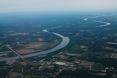
{{Image|Tennessee River Aerial - South Huntsville (38561504340).jpg|right|400px|The Tennessee River in 2014 as it snakes through Northern Alabama near Huntsville.}} | {{Image|Tennessee River Aerial - South Huntsville (38561504340).jpg|right|400px|The Tennessee River in 2014 as it snakes through Northern Alabama near Huntsville.}} | ||
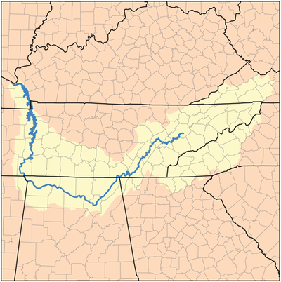
{{Image|Tennessee watershed.png|right|400px|The watershed of the Tennessee river.}} | {{Image|Tennessee watershed.png|right|400px|The watershed of the Tennessee river.}} | ||
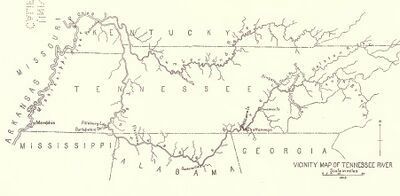
{{Image|TENN river.jpg|right|400px|The Tennessee river and its tributaries in 1915, before any part was dammed.<ref>From the book "Aboriginal Sites on Tennessee River" by Clarence B. Moore, reprinted from the Journal of The Academy of Natural Sciences of Philadelphia Vol. XVI, 1915. This view is from a screen shot from the PDF file, rotated and cropped. </ref>}} | {{Image|TENN river.jpg|right|400px|The Tennessee river and its tributaries in 1915, before any part was dammed.<ref>From the book "Aboriginal Sites on Tennessee River" by Clarence B. Moore, reprinted from the Journal of The Academy of Natural Sciences of Philadelphia Vol. XVI, 1915. This view is from a screen shot from the PDF file, rotated and cropped. </ref>}} | ||
The '''Tennessee River''' is the [[Ohio River]]'s largest tributary. Slicing twice through [[Tennessee (U.S. state)|Tennessee]], and passing through both [[Alabama (U.S. state)]] and [[Kentucky (U.S. state)|Kentucky]], the Tennessee river was 652 miles long in 1915, before any portions of it were dammed. Since the 1930's, the [[Tennessee Valley Authority]] (TVA) dammed the Tennessee and its tributaries in several places, vastly altering the flow of water and the ecology of the river valley. | The '''Tennessee River''' is the [[Ohio River]]'s largest tributary. Slicing twice through [[Tennessee (U.S. state)|Tennessee]], and passing through both [[Alabama (U.S. state)]] and [[Kentucky (U.S. state)|Kentucky]], the Tennessee river was 652 miles long in 1915, before any portions of it were dammed. Since the 1930's, the [[Tennessee Valley Authority]] (TVA) dammed the Tennessee and its tributaries in several places, vastly altering the flow of water and the ecology of the river valley. | ||
| Line 99: | Line 100: | ||
</references> | </references> | ||
[[Category:Suggestion Bot Tag]] | |||
Latest revision as of 16:00, 25 October 2024

The Tennessee River is the Ohio River's largest tributary. Slicing twice through Tennessee, and passing through both Alabama (U.S. state) and Kentucky, the Tennessee river was 652 miles long in 1915, before any portions of it were dammed. Since the 1930's, the Tennessee Valley Authority (TVA) dammed the Tennessee and its tributaries in several places, vastly altering the flow of water and the ecology of the river valley.
The river's upper half flows southward, and its lower half northward. The Tennessee river begins in East Tennessee a short distance above the city of Knoxville. It is formed by the junction of the French Broad and the Holston rivers. From the conjunction of those two rivers, the Tennessee river flows southwest until, south of and below the city of Chattanooga, it enters the state of Alabama.
In Alabama, the Tennessee river flows first southwest and then northwest past the Muscles Shoals (near Florence, AL), a shallow and unnavigable rapids, and the only unnavigable portion of the river. After the shoals, the river soon runs along the northeast corner of the state of Mississippi for about ten miles its western side. Then the river again enters the state of Tennessee, now flowing northward. It divides Middle Tennessee from West Tennessee. After passing through Tennessee, the river enters Kentucky and after 40 to 50 miles it flows into the Ohio river at Paducah.
Dams
Since the 1930's, the Tennessee itself has been dammed nine times. Those dams are shown here in their order along the river from its source to where it flows into the Ohio River:
- Fort Loudoun Dam, which created Fort Loudoun Lake near Knoxville, Tennessee
- Watts Bar Dam, which created Watts Bar Lake
- Chickamauga Dam, which created Chickamauga Lake
- Nickajack Dam, which created Nickajack Lake
- Guntersville Dam, which created Guntersville Lake
- Wheeler Dam (275 mi. above mouth) - created Wheeler Lake between Rogersville, Alabama and Huntsville, Alabama
- Wilson Dam (259 mi. above mouth) - created Wilson Lake near Muscles Shoals, Alabama
- Pickwick Landing Dam (207 mi. above mouth) - created Pickwick Lake just south of Savannah, Tennessee near where the borders of Mississippi, Alabama and Tennessee meet
- Kentucky Dam (2.3 mi, above mouth) - built in the 1930's near Paducah, Kentucky, to create Kentucky Lake
In addition, the river's dozens of tributaries have also been dammed in nearly two dozen places. The original goals of the Tennessee Valley Authority (TVA), created under Roosevelt during the Great Depression of the 1930's, was threefold: 1) to provide jobs, 2) to generate low-cost hydro-electric power, and 3) to contribute to flood control of the Mississippi River basin. While these goals were accomplished, a significant amount of environmental destruction (and other side effects) eventually caused the public, by the 1970's, to resist the building of any more dams than already exist.
Tributaries
There are more than two dozen tributaries to the Tennessee River, listed below in order from the river's mouth to its head.[2]
- Clarks River (TRM 4.3) - Mouth to Mile 20.2 (ELVA Bridge).
- West Fork Clarks River (Clarks River Mile 12.7) - Mouth to Mile 11.9 (Kahler Bridge).
- Blood River (TRM 50.7) - Mouth to Mile 9.7 Kentucky Highway 121 Bridge).
- Big Sandy River (TRM 67.0) - Mouth to Mile 52.6 (Carroll County Highway Bridge near Wilderville, Tennessee).
- West Fork Big Sandy River (Big Sandy River Mile 8.8) - Mouth to Mile 8.2 (Tennessee Highway 69 Bridge).
- Duck River (TRM 110.8) - Mouth to Mile 262.8 (Head of Slackwaters of Normandy Lake).
- Buffalo River (Duck River Mile 15.4) - Mouth to Mile 116.7 (Lawrence County Highway Bridge at Henryville, Tennessee).
- Beech River (TRM 135.7) - Mouth to Mile 21.6 (Henderson County Highway Bridge near Chesterfield, Tennessee).
- Yellow Creek (TRM 215.1) - Mouth to Mile 32.1 (Head, Tennessee Valley Divide).
- Bear Creek (TRM 224.7) - Mouth to Mile 130.0 (Head of Slackwaters of Upper Bear Creek).
- Cedar Creek (Bear Creek 27.7) - Mouth to Mile 38.3 (Head of Slackwaters of Cedar Creek Lake).
- Little Bear Creek (Cedar Creek 14.9) - Mouth to Mile 23.1 (Head of Slackwaters of Little Bear Creek Lake).
- Cedar Creek (Bear Creek 27.7) - Mouth to Mile 38.3 (Head of Slackwaters of Cedar Creek Lake).
- Cypress Creek (TRM 255.0) - Mouth to Mile 17.6 (Lauderdale County Bridge).
- Little Cypress Creek (Cypress Creek Mile 10.2) - Mouth to Mile 8.0 (Head of Slackwaters of Sharps Mill Lake).
- Shoal Creek (TRM 264.3) - Mouth to Mile 56.0 (Confluence with Little Shoal Creek).
- Factory Creek (Shoal Creek Mile 28.6) - Mouth to Mile 9.7 (Wayne County Highway Bridge 0.1 Mile Upstream of Couch Branch).
- Elk River (TRM 284.3) - Mouth to Mile 194.1 (US Highway 41 Bridge).
- Richland Creek (Elk River Mile 42.6) - Mouth to Mile 48.6 (Confluence with Clear Creek).
- Flint Creek (TRM 308.4) - Mouth to Mile 28.2 (Huckaba Bridge).
- Limestone Creek (TRM 310.7) - Mouth to Mile 32.0 (Confluence with Little Limestone Creek).
- Flint River (TRM 339.1) - Mouth to Mile 51.2 (Madison County Highway Bridge).
- Paint Rock River (TRM 339.1) - Mouth to Mile 60.0 (Confluence of Estill Fork and Hurricane Creek).
- Estill Fork (Paint Rock River 60.0) - Mouth to Mile 10.0 (Confluence of Keller and Dry Creeks).
- Hurricane Creek (Paint Rock River Mile 60.0) - Mouth to Mile 7.4 (John Gifford Hollow).
- Town Creek (TRM 360.8) - Mouth to Mile 14.0 (High Falls).
- Short Creek (TRM 360.8) - Mouth to Mile 6.5 (Short Creek Falls).
- Crow Creek (TRM 401.1) - Mouth to Mile 33.7 (Confluence with Dry Creek).
- Sequatchie River (TRM 422.7) - Mouth to Mile 86.3 (Site of Cooper Mill Dam).
- Little Sequatchie River (Sequatchie River Mile 8.0) - Mouth to Mile 8.0 (One Mile North of Coppinger Chapel).
- South Chickamauga Creek (TRM 468.2) - Mouth to Mile 17.3 (Tennessee-Georgia State Line).
- West Chickamauga Creek (South Chickamauga Creek 13.5) - Mouth to Mile 3.2 (Tennessee-Georgia State Line).
- North Chickamauga Creek (TRM 470.9) - Mouth to Mile 17.4 (U.S. Highway 27 Bridge).
- Hiwassee River (TRM 500.3) - Mouth to Mile 65.8 (Tennessee-North Carolina State Line).
- Ocoee River (Hiwassee River Mile 34.4) - Mouth to Mile 38.8 (Tennessee-Georgia State Line).
- Piney River (TRM 532.5) - Mouth to Mile 8.9 (Confluence with Soak Creek).
- Clinch River (TRM 567.7) - Mouth to Mile 202.1 (Tennessee-Virginia State Line).
- Emory River (Clinch River Mile 4.4) - Mouth to Mile 45.3 (Site of Macedonia Church).
- Obed River (Emory River Mile 2.84) - Mouth to Mile 34.5 (U.S. Highway 127 Bridge).
- Clear Creek (Obed River Mile 4.4) - Mouth to Mile 29.0 (U.S. Highway 127 Bridge).
- White Creek (Clear Creek Mile 8.8) - Mouth to Mile 8.9 (Twin Bridges).
- Daddys Creek (Obed River Mile 9.1) - Mouth to Mile 33.9 (Tennessee Highway 28 Bridge).
- Clear Creek (Obed River Mile 4.4) - Mouth to Mile 29.0 (U.S. Highway 127 Bridge).
- Poplar Creek (Clinch River Mile 12.0) - Mouth to Mile18.3 (Tennessee Highway 61 Bridge) .
- Powell River (Clinch River Mile 88.8) - Mouth to Mile 115.7 (Tennessee-Virginia State Line).
- Obed River (Emory River Mile 2.84) - Mouth to Mile 34.5 (U.S. Highway 127 Bridge).
- Emory River (Clinch River Mile 4.4) - Mouth to Mile 45.3 (Site of Macedonia Church).
- Little Tennessee River (TRM 601.3) - Mouth to Mile 49.4 (Tennessee-North Carolina State Line).
- Tellico River (Little Tennessee River Mile 19.2) - Mouth to Mile 37.0 (One Mile Downstream of Bald River Falls).
- Little River (TRM 635.6) - Mouth to Mile 50.5 (at Elkmont, Tennessee).
- Holston River (TRM 652.1 - Mouth to Mile 142.2 (Head, Confluence of North and South Fork Holston River).
- North Fork Holston River (Holston River Mile 142.2) - Mouth to Mile 5.0 (Tennessee-North Carolina State Line).
- South Fork Holston River (Holston River Mile 142.2) - Mouth to Mile 73.3 (Head, Slackwaters of South Holston Lake).
- Watauga River (South Fork Holston River 19.9) - Mouth to Mile 55.1 (Tennessee-North Carolina State Line).
- Doe River (Watauga River Mile 26.4) - Mouth to Mile 22.7 (1.4 Mile SSW of Roan Mountain).
- Elk River River (Watuaga River Mile 46.8) - Mouth to Mile 14.5 (Tennessee-North Carolina State Line).
- Middle Fork Holston River (South Fork Holston River Mile 72.3) - Mouth to Mile 1.3 (Head, Slackwaters of South Holston Lake).
- Watauga River (South Fork Holston River 19.9) - Mouth to Mile 55.1 (Tennessee-North Carolina State Line).
- French Broad River (TRM 652.1) - Mouth to Mile 102.6 (Tennessee-North Carolina State Line).
- Little Pigeon River (French Broad River Mile 27.4) - Mouth to Mile 25.5 (Highway 73 Bridge).
- West Prong Little Pigeon River (Little Pigeon River Mile 4.7) - Mouth to Mile 12.3 (Chapmans Highway Bridge).
- East Prong Little Pigeon River (Little Pigeon River Mile 9.6) - Mouth to Mile 11.0 (Confluence of Long Branch and Dunn Creek).
- Nolichucky River (French Broad River Mile 69.1) - Mouth to Mile 100.8 (Tennessee-North Carolina State LIne).
- Lick Creek (Nolichucky River Mile 16.0) - Mouth to Mile 49.8 (Lick Creek Mill).
- Pigeon River (French Broad River Mile 73.8) - Mouth to Mile 25.9 (Tennessee-North Carolina State Line).
- Little Pigeon River (French Broad River Mile 27.4) - Mouth to Mile 25.5 (Highway 73 Bridge).
Notes
- ↑ From the book "Aboriginal Sites on Tennessee River" by Clarence B. Moore, reprinted from the Journal of The Academy of Natural Sciences of Philadelphia Vol. XVI, 1915. This view is from a screen shot from the PDF file, rotated and cropped.
- ↑ Tennessee River and Tributaries on the website of the US Army Corps of Engineers, Nashville, District. Last access 12/16/2023.

