Colorado River (U.S.)
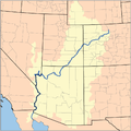
The Colorado River is a 1,450-mile-long river whose highly litigated waters are a lifeline in an arid region. The river starts in the Rocky Mountains of Colorado and flows southwest, then south, through Utah, Arizona, Nevada, California, and Mexico. Its headwaters begin at the continental divide in the center of Colorado, and its lowest part crosses Mexico between Baja and Sonora to flow into the Gulf of California. The river passes through 11 different national parks and monuments of varied landscapes, including the Grand Canyon and Hoover Dam.
Large-scale river management began in the early 1900s. With all of its waters fully allocated, there is more demand for its waters than can be accommodated, resulting in extensive ongoing legal battles. In particular, the lower Colorado provides water to Las Vegas, Los Angeles, San Diego, Phoenix, and Tucson. Upstream, the Colorado has been drastically depleted due to people are taking too much water out of the river basin and also due to drought exacerbated by climate change. The region the Colorado River flows through is the driest it has been in 1200 years.
In April 2023 as the river shrinks, the Biden administration is getting ready to impose, for the first time, reductions in water supplies to states. The plan would cut the water delivered to California, Arizona and Nevada by as much as one-quarter, and the reduction would be divided evenly across all the states.[1]
Gallery
Notes
- ↑ White House Proposes Evenly Cutting Water Allotments From Colorado River 4-11-2023 at the New York Times.


