Revision as of 13:24, 26 January 2012 by imported>Milton Beychok
Summary
| Title / Description
|
NASA's Composite of satellite images of Earth
|
| Author(s)
|
National Aeronautics and Space Administration
|
| Source
|
http://www.nasaimages.org/luna/servlet/detail/nasaNAS~5~5~24325~127710:Satellite-Image-of-Earth-s-Interrel?fullTextSearch=fullTextSearch&qvq=q:Satellite%2BImage%2Bof%2BEarth%27s%2BInterrelated%2BSystems%2Band%2BClimate;lc:NVA2~25~25,NVA2~81~81,NVA2~57~57,NVA2~31~31,NVA2~60~60,NVA2~33~33,NVA2~26~26,NVA2~74~74,NVA2~36~36,NVA2~62~62,NVA2~56~56,NVA2~55~55,NVA2~54~54,NVA2~45~45,NVA2~35~35,NVA2~53~53,NVA2~75~75,NVA2~29~29,NVA2~27~27,NVA2~17~17,NVA2~84~84,NVA2~85~85,NVA2~46~46,NVA2~30~30,NVA2~44~44,NVA2~16~16,NVA2~47~47,NVA2~48~48,NVA2~61~61,NVA2~19~19,NVA2~52~52,NVA2~4~4,NVA2~1~1,nasaNAS~22~22,NVA2~20~20,nasaNAS~8~8,nasaNAS~10~10,NVA2~15~15,nasaNAS~13~13,nasaNAS~5~5,NVA2~18~18,NVA2~23~23,NVA2~8~8,nasaNAS~16~16,nasaNAS~2~2,NVA2~34~34,NVA2~14~14,nasaNAS~7~7,nasaNAS~6~6,NVA2~24~24,NVA2~13~13,nasaNAS~9~9,nasaNAS~4~4,NVA2~58~58,NSVS~3~3,NVA2~9~9,nasaNAS~20~20,nasaNAS~12~12,NVA2~21~21,NVA2~22~22,NVA2~78~78,NVA2~63~63,NVA2~49~49,NVA2~50~50,NVA2~51~51,NVA2~28~28,NVA2~43~43,NVA2~38~38,NVA2~80~80,NVA2~32~32,NVA2~37~37,NVA2~39~39,NVA2~41~41,NVA2~42~42,NVA2~59~59,NVA2~76~76,NVA2~82~82,NVA2~79~79,NVA2~86~86&mi=0&trs=1
|
| Date created
|
Sept. 18, 1997
|
| Country of first publication
|
United States
|
| Notes
|
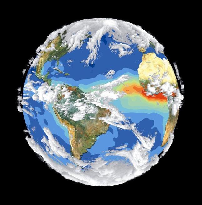
Four different satellites contributed to the making of this image. Sea-viewing Wide Field-of-view Sensor (SeaWiFS) provided the land image layer and is a true color composite of land vegetation for cloud-free conditions. Four different satellites contributed to the making of this image. Sea-viewing Wide Field-of-view Sensor (SeaWiFS) provided the land image layer and is a true color composite of land vegetation for cloud-free conditions. The cloud layer is a composite of infrared images from four geostationary weather satellites.
|
| Other versions
|
If there are other versions of this media on CZ, please list them here.
|
| Using this image on CZ
|
Copy the code below to add this image to a Citizendium article, changing the size, alignment, and caption as necessary.
{{Image|NASACompositeSatelliteImageOfEarth.jpg|right|350px|Add image caption here.}}
To edit the credit line, click here.
|
Image issue? Contact us via the email below.
Please send email to manager A T citizendium.org .
Licensing
This media, NASACompositeSatelliteImageOfEarth.jpg, is in the public domain
This is a work of the United States Government, and as such is not afforded copyright protection under US law.
For further information see Title 17, Chapter 1, Section 105 of the US Code.
You may freely copy, distribute, display and perform this work, as well as make derivative and commercial works.
File history
Click on a date/time to view the file as it appeared at that time.
| Date/Time | Thumbnail | Dimensions | User | Comment |
|---|
| current | 19:51, 11 March 2022 | 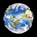 | 645 × 652 (56 KB) | Maintenance script (talk | contribs) | == Summary == Importing file |
You cannot overwrite this file.
File usage
The following 3 pages use this file: