Myron C. Lake
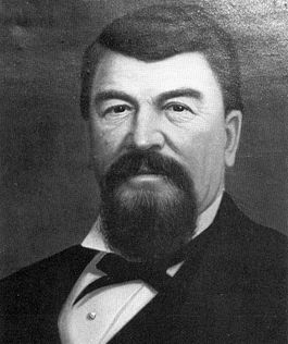
Myron Charles Lake (Feb. 1828-June 20, 1884), hotel-keeper/entrepreneur, was the hot-tempered, tight-fisted founder of Reno, Nevada. Between 1862 and 1873, Lake lorded over the town through his vast real estate holdings and monopolistic control of a vitally important toll bridge and road. He quickly assumed the posture of a stereotypical "robber baron," and in an unhappy marriage, often resorted to domestic violence. But he also wielded a keen business acumen and in so doing, ensured that the Central Pacific Railroad during the building of the great transcontinental project would run through Reno, thereby sparking the growth and prosperity of western Nevada.
Early life
Very little is known about Lake’s early years and much of what is known remains unclear. He was born in Cayuga County, New York state, the oldest of 7 children (5 boys, 2 girls) born to Catherine Van Tassell (1803-1874) of New York state and John Lake (1799-1877), of Maine. About 1839, the family moved to Paw Paw, DeKalb County, Illinois, about 70 miles west of Chicago.[1] Lake saw service during the Mexican-American War (1846-48) as an infantry private in Illinois’ volunteer Company D, First Regiment. Following the war, he returned home to establish a farm of 300 acres, comprised of a 160-acre federal land grant in appreciation of his service, and his personal acquistion of the rest.[2]
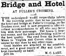
By 1852, he had moved on to Rabbit Creek, Calif. to try his hand at mining;[3] five years later, he moved intrastate to Honey Lake Valley, where he built a modest ranch. Evidence indicates that, in October 1857, Lake played prominently in vigilante apprehensions of both Indians and outlaws. It was here that he met former Missourian Charles W. Fuller from whom Lake would, in June 1861 acquire Fuller's Crossing, a small way station, road, and flimsy log bridge over the Truckee River at today's Virginia Street in exchange for Lake's meager California ranch.[4]
Lake’s Crossing
Fuller's rough going failed to make a negative impression on Lake; he could see only flashing dollar signs. He was intent on transforming the little crossing into a great commercial venture.[5] But before Lake had any real time to make significant improvements, all bridges across the Truckee River were swept away by the torrential flooding of early spring 1862. Upon rebuilding, Lake's first action was to guarantee that only he would control traffic over the new Lake's Crossing. He petitioned for and won from Nevada's Territorial legislature a ten-year exclusive franchise to operate his toll bridge and road at that location. Now, no one else within a mile could replicate Lake's setup, and a brief period of relaxation appeared to be in order. In 1864, he returned briefly to Honey Lake Valley to wed Jane Conkey Bryant, whose family had been Lake's neighbors there. They were married in nearby Janesville, Calif. on September 11.[6]
Despite his monopoly, nearly six years passed before Lake's fortunes began to skyrocket with the arrival of the Central Pacific Railroad (CPRR), such was the difficulty of competing with other more favored crossings. In the meantime, Lake's bridge withstood yet another flood in 1867 and he proceeded to invest his toll incomes to spawn important improvements: the shrewd purchase of a robust 137 acres on both sides of the Truckee destined to become Reno; a grist mill above the north bank; and several additions/improvements to his inn including stables and a barn below the south bank.[7]
Most likely, it was Lake who first contacted CPRR construction superintendent Charles Crocker with an offer to provide land for a town site and the railroad's right-of-way if it would construct a depot at his crossing. Both parties knew a very good thing when they saw it. The public first heard of the deal in late February 1868 and one month later it was sealed: Lake traded roughly 105 acres north of the river and a net payment of $75 for the railroad's acreage south of the river and its promise to return to Lake certain northside lots.[8] The abruptly spiking real estate values made Lake one of the state's richest men. CPRR personnel surveyed borders for the new town on April 1st, divided it into 25 ft. by 100 ft. parcels, and named its streets. President Leland Stanford prevailed upon the remaining members of the railroad's "Big Four" to officially rename the heretofore barren settlement Reno, honoring U.S. Army Major General Jesse Lee Reno, a Union hero of the Civil War. The town's official birthday: May 9, 1868, the day the railroad auctioned off 400 northside lots for, in some cases, more than $1000 each. And with that, the newly born town was off and running. The first train chugged through Reno just six weeks later, and by mid-July the town boasted hundreds of shops, bustling rail traffic, and a burgeoning population of between 1000-2000. It had already become "a real, wide-awake, flourishing little town." A local newspaper exulted, "Bully for Reno."[9]
Dark Side
Lake reached the pinnacle of his success in these days immediately following the railroad's maiden passage through Reno. To have denied him the title, Lord and Master of all he surveyed, would have been a pointless quibble. He owned half the town's northside real estate, almost everything worth owning on the south side including a 900-acre ranch (by 1884), his hotel Lake House, and his toll road/bridge franchise, which would not expire until December 1872. One pained spectator compared him derisively to "a wolf in sheep's clothing...who ever stands ready to gobble up unwary innocents."[10] Lake had no need to consider the existence, let alone the complaints, of either the townspeople or his family, and his conduct toward both arrogantly reflected his evident lack of consideration for others.
While Lake was single-mindedly accumulating his riches, his domestic life rapidly disintegrated. He suffered from a fiery temper that found its outlet in domestic battery. In divorce court, Jane Lake detailed several instances of her husband's penchant for spousal abuse. The first came in June 1870 when while "cruelly and brutally" beating his wife to the ground, he blurted, "I have a good mind to kill you." Similar incidents followed in 1876 and 1879. In the former, Lake, unleashed a series of foul profanities, again knocked his wife down, and later told his hotel manager Edward Vesey that the infant Charlie was not his son. In the latter, Lake told Jane "that he wanted to be rid of her-that she could go to hell[;] that if she would go where he would never see her again he would give her $10,000!" A few months later, Lake accused her of being unfaithful with longtime employee, William Roberts. All told, Jane Lake tolerated her husband's terrorizing insanity for nearly a decade before filing in late 1879 for dissolution of the marriage on grounds of cruelty. After an agonizingly drawn-out court battle featuring sordid details galore, she was granted the divorce on April 8, 1881; the property settlement dragged on for another 3 years."[11]
A Bridge Too Close
More trouble was in store for Lake when his exclusive franchise to collect tolls across his bridge expired on December 17, 1872. His application for an extension was denied, but he knew that he could continue to collect tolls only if someone physically prevented him from doing so. He proceeded to defy the expiration date through at least February 1, 1873 even though the Washoe County commissioners had declared the road/bridge free and open to all on January 6. What happened during one of Lake's barricades on January 20 evoked "amusement" from "a large number of idlers" who gathered at the site. In a scene reminiscent of the late 6th century B.C. poet Horatius Cocles, Lake mounted the bridge, locked its gate, and brandishing a Colt revolver warned off anyone from crossing without remitting a toll. Lake was hauled into court but released after it ruled that it had no jurisdiction in the matter. In his obstruction of January 27, Lake was again brought before a magistrate and fined. An officer was installed to keep the bridge open. The matter ultimately landed in Nevada Supreme Court where Lake's monopoly was officially terminated on May 26, 1873.[12]
Legacy
Notes
- ↑ John Lake was a Baptist farmer, buried next to his son in Reno's Mountain View Cemetery. In 1873, John and Catherine relocated to Reno; they moved in with Myron and Jane at their Junction House ranch (today's intersection of S. Virginia Street and Peckham Lane). Townley, pp. 148, 166. For 1839 as the Illinois relocation year: J. Lake obituary, REG, Jan. 16, 1877, p. 2. Catherine Lake remained in Reno only six months before returning to Illinois because she "could not accommodate herself to the country, its people and customs." She died on Jan. 29, 1874. RC, Feb. 5, 1874, p. 2.
- ↑ Ancestry.com, 1850 U.S. Federal Census [database on-line]. Provo, Utah, USA: The Generations Network, Inc., 2005; Illinois State Archives, Springfield, Ill., Illinois Mexican War Veterans Database, accessed Jan. 30, 2008. The government's award of free land was dated June 11, 1849; accessed Jan. 30, 2008 click here.
- ↑ Lake's obituary in the NSJ (June 21, 1884, p. 3) gives the year as 1851. Rabbit Creek lies very near the tiny town of La Porte, in the Sierra about 65 miles west-southwest of the Truckee Meadows.
- ↑ Fuller is said to have also thrown in $1500. His idea, ahead of Lake, was to serve miners trudging to and from the Comstock. Fuller's station made for a considerably shorter and easier crossing than the existing Stone & Gates' bridge, about four miles east of his. But at least two bridge washouts, a bankruptcy, and competition from existing fords convinced Fuller that it was time to try something else. Townley, pp. 52-53, 57, 63.
- ↑ It seems safe to assume that both Fuller and Lake had prior knowledge of the coming of the railroad through the Truckee Meadows and that it appeared all but certain as early as 1862 (Rocha, p. 28; Bain, p. 111). But Fuller, being flat broke and roundly discouraged, had been blinded to the possibility of success that Lake foresaw and had the financial wherewithal to exploit.
- ↑ Townley, pp. 53-54. Their only child, Myron Charles Jr., known always as "Charlie," was born on Nov. 26, 1875. There appears to be no evidence that Myron Sr. battered Charlie. It was the second marriage for both. Not a single thing is known about Lake's first marriage, except that it occurred in California. Jane Conkey had been married in Wisconsin to John Prince Bryant, killed in the Civil War in October 1862. Grappling with poverty and at her wit's end, she then joined her parents in California in July 1863.
- ↑ A Dec. 1868 fire levelled this structure. The new hotel, the sparkling white 'Lake House', was ready for business in March 1869. Townley, pp. 53-54, 148. Lake's 1864 acquisition of the riverside acreage, approx. 75 north, 62 south of the river at Virginia Street, consisted of the heart of Reno as well as what became the CPRR's right of way. It could hardly have been more commercially prescient. It can be found in Lake Papers, U.S. Land Office, Carson City, C.A. Witherell to Robert M. Clarke, Reno, Nev., May 18, 1881. "Final proof of payment was made August 3, 1864 and duplicate receipt issued on same date"; patent issued Aug. 10, 1865. See also the BLM record, with the patentee name in error: here.
- ↑ Washoe County (Nev.) Recorder, Deed Book #2, pp. 360-61, 430-31; Deed book #3, 673-74. See Appendix 1. '105' acres is an approximation of the 3/27/68 transaction based on visually examining the plat of Section 11. The deed book does not enumerate the acreage.
- ↑ Townley, pp. 54, 67, 70-71; Rocha, p. 28. In 1984, Darwin Flaherty (see References) cleared up much of the confusion regarding the adoption of 'Reno'. 'Argenta', the preference of Edwin B. "Judge" Crocker (older brother of Charles), was first proclaimed in the April 6 Sacramento Bee and remained in use for a little over two weeks. Then very mysteriously and quite abruptly, 'Argenta' vanished and 'Reno' took its place for the first time in the April 23 Auburn (Calif.) Stars and Stripes. To be sure, Flaherty could have fashioned a less convoluted explanation, but he nevertheless makes a strong case refuting Charles Crocker as Reno's namer (as legend had it). Flaherty shows persuasively that Stanford was good friends with U.S. Army General Irvin McDowell, who had been in close Civil War combat with Generals Reno and James S. Wadsworth, and wanted their surnames memorialized. As a gesture of friendship for McDowell, Stanford won the agreement of the remaining associates to use the last names of McDowell's fallen comrades as CPRR station names. Also of note in Flaherty's article is the injunction to readers that the role of E.B. Crocker in CPRR decisions is not to be underestimated (p. 155, n.1). During this time at least, "the Judge" was, for all intents and purposes, a fifth associate.
- ↑ RC, Jan. 21, 1871, p. 2, quoted in Townley, p. 147.
- ↑ Complaint, Jane Lake vs. M.C. Lake, 1879 Plaintiff's Complaints File, Lake Papers, filed Dec. 12, 1879, pp. 1-2; Townley, p. 148. Notice of the divorce decree was published the same day in the REG, p. 3. Jane Lake received none of Lake's property, but she was awarded monthly alimony of $200 and custody of Charlie. During the trial Lake also claimed that son-in-law William Thompson had been scheming to embezzle his estate.
- ↑ Rocha, pp. 29, 62; Townley, pp. 73, 147, 166 n.11; RC, Jan. 23, 1873, p.3; Feb. 8, 1873, p.3; NSJ, Feb. 1, 1873, p.3; May 28, 1873, p.3. Following the Jan. 20 incident, the idlers were "hugely disgusted when they found that there would be no one hurt." John Townley referred to this as Lake's "Horatio at the Bridge" moment; said title being a children's poem adapted from "Horatius" (1842) by Lord T.B. MacCaulay. See the poem here.
References
There is no single biography and even now much information remains to be collected, especially with regard to Lake's pre-Nevada life. He left no diaries or journals. The Myron C. Lake Papers, which contain among other documents, the record of his divorce proceedings, can be found at the Nevada Historical Society in Reno. Click on this article's Discussion page for a gallery of early Lake/Reno images.
- Bain, David Haward. Empire Express: Building the First Transcontinental Railroad (New York: Viking Penguin, 1999).
- Flaherty, Darwin L. "The Naming of Reno, Nevada: a Century-Old Mystery," Nevada Historical Society Quarterly 27,3(Fall 1984), pp. 155-81.
- Lake, Myron C. Papers (MS RNC 128), 1 box, Nevada Historical Society, Reno. cited as Lake Papers.
- Newspapers: Nevada State Journal (NSJ); Reno Crescent (RC); Reno Evening Gazette (REG).
- Rocha, Guy Louis. “Reno’s First Robber Baron,” Nevada Magazine 40,2(March-April, 1980), pp. 28-29, 62.
- Townley, John M. Tough Little Town on the Truckee: Reno, 1868-1900 (Reno: Great Basin Studies Center, 1983).
Appendix 1: The Deal that Made Reno
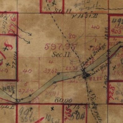
As found in the Washoe County Recorder's office, here are the three transactions that traded the land that became Reno. The key tract is Section 11 of Township 19 North, Range 19 East. Follow the first two using the map of Section 11 to the right. The third can be located on the CPRR's First Map of Reno. A township is 36 sq. miles; a section is 1 sq. mile or 640 acres. Each sixteenth of a section is 40 acres. For more on sections, townships, and ranges, see this page.
In essence, the deal consisted of a nearly equal land trade which resulted in a net $75 payment from Lake to the railroad, along with its return to Lake of 13 northside lots (10 and 11 of Block V; the two of Lake's Reserve; odd numbers 33-51 east of Virginia St.) 9 months later. In the first transaction, Lake turned over the northside to Crocker. In the second, Crocker traded the southside, minus the riverfront, which remained Lake's via his 1864 acquisition. In the third, Crocker returned the northside parcels.
1) Lake to Chas. Crocker, 3/27/68, recorded 3/30/68, (bk.#2,pt.1), pp. 360-61, $200 - no acreage given, but approximates 105. [1] "...the South half of the North East quarter; [2] and the fractions lying North of the Truckee River of the North Half of the South East quarter. all in Sec. 11..."
2) CPRR deed #289 to Lake, 3/24/68, recorded 7/6/68, (#2,2), pp. 443-44, $275 - 109 acres. [1] "the South half of the South East Quarter and; [2] Lot No. 7 of the South West Quarter of Sec. No. 11..."
3) Chas. Crocker to Lake, 12/28/68, recorded 2/1/69, (#3,1), pp. 673-74. $1 (gift) - no acreage given. [1] "Lots no. 10 and 11, including the space of 14 ft., 2 in. more or less between lots 11 and 12 in Block V being the north 114 ft and 2 in. of the East half of Block V aforesaid. [2] also 150 ft. front on Front St. on the South side commencing at the East line of Virginia St. and extending back to the river the same width. [3] also: 100 ft. front on Front St. measuring West. commencing at the West line of Virginia St. on the South side of said Front Street. both parcels of land being designated on the map as 'Lake's Reserve'. [4] also, lots in the river front East of Lake's Reserve. East of Virginia St. numbered 33,35,37,39,41,43,47,49,51. each being 25 ft. front extending back to the river."


