File:BF Gulf stream map.jpg: Difference between revisions
imported>Caesar Schinas m (Robot: Changing template: PD-butrequest) |
imported>Caesar Schinas m (Replace Template:Information with Template:Image_Details) |
||
| Line 1: | Line 1: | ||
== Summary == | == Summary == | ||
{{ | |||
{{Image_Details | |||
| description = Chart of the Gulf Stream drawn by Benjamin Franklin | |||
| author = Benjamin Franklin, photocopy by National Oceanic and Atmospheric Administration | |||
| copyright = Benjamin Franklin, photocopy by National Oceanic and Atmospheric Administration | |||
| source = http://www.oceanexplorer.noaa.gov/library/readings/gulf/media/gulf_bf.html | |||
| date-created = [1780] | |||
| pub-country = | |||
| notes = | |||
| versions = | |||
}} | |||
== Licensing/Copyright status == | |||
http://www.photolib.noaa.gov/aboutimages.html | |||
Revision as of 04:26, 22 June 2009
Summary
| Title / Description
|
Chart of the Gulf Stream drawn by Benjamin Franklin |
|---|---|
| Author(s)
|
Benjamin Franklin, photocopy by National Oceanic and Atmospheric Administration |
| Copyright holder
|
Benjamin Franklin, photocopy by National Oceanic and Atmospheric Administration See below for license/re-use information. |
| Source
|
http://www.oceanexplorer.noaa.gov/library/readings/gulf/media/gulf_bf.html |
| Date created
|
[1780] |
| Country of first publication
|
Please edit this page and add the country of first publication, or note that it is unknown. |
| Notes
|
You can edit this page and add notes here which may be useful to people who wish to re-use this media. |
| Other versions
|
If there are other versions of this media on CZ, please list them here. |
| Using this image on CZ
|
, then copy the code below to add this image to a Citizendium article, changing the size, alignment, and caption as necessary.
|
Please send email to manager A T citizendium.org .
Licensing/Copyright status
http://www.photolib.noaa.gov/aboutimages.html
Licensing/Copyright status
This media, BF Gulf stream map.jpg, is in the public domain
However, the entity or person who possesses the physical copy and/or has made this work available has made certain requests of re-users of it.
See the Permission page for details.
Notice of possible CC-by-sa incompatibility
Text on the Citizendium is licensed under the Creative Commons Attribution ShareAlike licence.
This media may be incompatible with those terms except by separate agreement with the copyright holder.
File history
Click on a date/time to view the file as it appeared at that time.
| Date/Time | Thumbnail | Dimensions | User | Comment | |
|---|---|---|---|---|---|
| current | 19:57, 11 March 2022 | 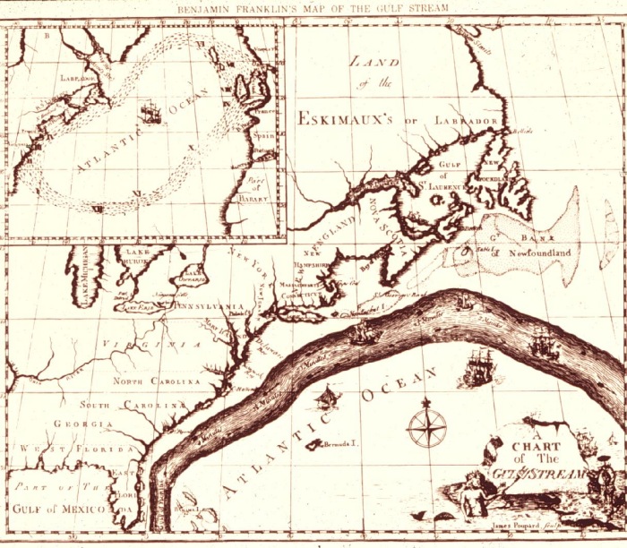 | 700 × 612 (184 KB) | Maintenance script (talk | contribs) | == Summary == Importing file |
You cannot overwrite this file.
File usage
The following 3 pages use this file: