Zambia: Difference between revisions
imported>David E. Volk No edit summary |
imported>David E. Volk No edit summary |
||
| Line 1: | Line 1: | ||
{{subpages}} | {{subpages}} | ||
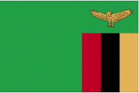
[[Image:Flag of Zambia.gif| | [[Image:Flag of Zambia.gif|200px|thumb|right|Flag of Zambia. {{PD-image|CIA}}]] | ||
'''Zambia''', officially the '''Republic of Zambia''', is a [[country]] in the southern part of [[Africa]]. Its name comes from the Zambezi River, the fourth-largest [[river]] in Africa, which begins precisely in this country. Its official language is [[English language|English]], although other vernaculars exist. Its [[capital]] and largest [[city]] is [[Lusaka]], located in south-central Zambia. It is a landlocked country. It is located in the Central Africa [[time zone]]. It was formerly known as Northern Rhodesia until it gained its independence from the [[United Kingdom]] in 1964. Its government type is a [[republic]]. | '''Zambia''', officially the '''Republic of Zambia''', is a [[country]] in the southern part of [[Africa]]. Its name comes from the Zambezi River, the fourth-largest [[river]] in Africa, which begins precisely in this country. Its official language is [[English language|English]], although other vernaculars exist. Its [[capital]] and largest [[city]] is [[Lusaka]], located in south-central Zambia. It is a landlocked country. It is located in the Central Africa [[time zone]]. It was formerly known as Northern Rhodesia until it gained its independence from the [[United Kingdom]] in 1964. Its government type is a [[republic]]. | ||
| Line 7: | Line 7: | ||
Zambia is divided into nine provinces. These are the Central, Western, Southern, North-Western, Northern, and Eastern provinces, along with Copperbelt, Luapula, and Lusaka. <ref>http://www.statoids.com/uzm.html</ref> Each province is subdivided into 72 districts. <ref>http://www.statoids.com/yzm.html</ref> | Zambia is divided into nine provinces. These are the Central, Western, Southern, North-Western, Northern, and Eastern provinces, along with Copperbelt, Luapula, and Lusaka. <ref>http://www.statoids.com/uzm.html</ref> Each province is subdivided into 72 districts. <ref>http://www.statoids.com/yzm.html</ref> | ||
==Geography== | ==Geography== | ||
[[Image:Zambia.gif|right|thumb|200px|{{#ifexist:Template:Zambia.gif/credit|{{Zambia.gif/credit}}<br/>|}}Add image caption here.]] | |||
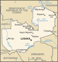
Zambia has a total of 752,614 mi² of territory. It is the 47th largest country in the world. <ref>https://www.cia.gov/library/publications/the-world-factbook/rankorder/2147rank.html</ref> It is bordered by [[Tanzania]] to the northeast, [[Malawi]] to the east, [[Mozambique]] and [[Zimbabwe]] to the southeast, [[Botswana]] and [[Namibia]] to the south, [[Angola]] to the west, and [[Zaire]] to the northwest. The majority of the country's landmass is located in a high plateau, lying between 3,500 and 4,500 feet above sea level. <ref>http://www.africaguide.com/country/zambia/</ref><ref>http://www.zambiatourism.com/travel/hisgeopeop/geograph.htm</ref> Its climate is tropical, and its rainy season lasts from October to April. <ref name=CIA>https://www.cia.gov/library/publications/the-world-factbook/geos/za.html</ref> The Zambezi River, which is 1,650 mi miles long, making it the fourth-largest in the [[continent]], begins in Zambia and flows into the Indian Ocean. <ref>http://encarta.msn.com/encyclopedia_761566589/Zambezi.html</ref> | Zambia has a total of 752,614 mi² of territory. It is the 47th largest country in the world. <ref>https://www.cia.gov/library/publications/the-world-factbook/rankorder/2147rank.html</ref> It is bordered by [[Tanzania]] to the northeast, [[Malawi]] to the east, [[Mozambique]] and [[Zimbabwe]] to the southeast, [[Botswana]] and [[Namibia]] to the south, [[Angola]] to the west, and [[Zaire]] to the northwest. The majority of the country's landmass is located in a high plateau, lying between 3,500 and 4,500 feet above sea level. <ref>http://www.africaguide.com/country/zambia/</ref><ref>http://www.zambiatourism.com/travel/hisgeopeop/geograph.htm</ref> Its climate is tropical, and its rainy season lasts from October to April. <ref name=CIA>https://www.cia.gov/library/publications/the-world-factbook/geos/za.html</ref> The Zambezi River, which is 1,650 mi miles long, making it the fourth-largest in the [[continent]], begins in Zambia and flows into the Indian Ocean. <ref>http://encarta.msn.com/encyclopedia_761566589/Zambezi.html</ref> | ||
==Demography== | ==Demography== | ||
Revision as of 09:16, 14 March 2008

Zambia, officially the Republic of Zambia, is a country in the southern part of Africa. Its name comes from the Zambezi River, the fourth-largest river in Africa, which begins precisely in this country. Its official language is English, although other vernaculars exist. Its capital and largest city is Lusaka, located in south-central Zambia. It is a landlocked country. It is located in the Central Africa time zone. It was formerly known as Northern Rhodesia until it gained its independence from the United Kingdom in 1964. Its government type is a republic.
Divisions
Zambia is divided into nine provinces. These are the Central, Western, Southern, North-Western, Northern, and Eastern provinces, along with Copperbelt, Luapula, and Lusaka. [1] Each province is subdivided into 72 districts. [2]
Geography
Zambia has a total of 752,614 mi² of territory. It is the 47th largest country in the world. [3] It is bordered by Tanzania to the northeast, Malawi to the east, Mozambique and Zimbabwe to the southeast, Botswana and Namibia to the south, Angola to the west, and Zaire to the northwest. The majority of the country's landmass is located in a high plateau, lying between 3,500 and 4,500 feet above sea level. [4][5] Its climate is tropical, and its rainy season lasts from October to April. [6] The Zambezi River, which is 1,650 mi miles long, making it the fourth-largest in the continent, begins in Zambia and flows into the Indian Ocean. [7]
Demography
As of a July 2007 estimate, Zambia has a total population of 11,477,447. This, however, changes constantly, due to the high mortality rates caused by AIDS. [6] The two major ethic groups in Zambia are African and European, which make up 99.8% of the population. [8] Zambia is a predominantly Christian country, the Roman Catholic Church being the largest single denomination. [9] Other major religions include Hinduism, Islam, and indigenous beliefs. [10] The official language spoken in Zambia is English, although many other are spoken, especially Bantu dialects, like Bemba, Lunda, and Tonga. [11]
References
- ↑ http://www.statoids.com/uzm.html
- ↑ http://www.statoids.com/yzm.html
- ↑ https://www.cia.gov/library/publications/the-world-factbook/rankorder/2147rank.html
- ↑ http://www.africaguide.com/country/zambia/
- ↑ http://www.zambiatourism.com/travel/hisgeopeop/geograph.htm
- ↑ 6.0 6.1 https://www.cia.gov/library/publications/the-world-factbook/geos/za.html
- ↑ http://encarta.msn.com/encyclopedia_761566589/Zambezi.html
- ↑ http://rainforests.mongabay.com/deforestation/2000/Zambia.htm
- ↑ http://www.britannica.com/eb/article-44124/Zambia
- ↑ http://news.bbc.co.uk/2/hi/africa/country_profiles/1069294.stm
- ↑ http://www.mapsofworld.com/zambia/culture/language.html
