File:Japanese Map of Dokdo 2.jpg: Difference between revisions
Jump to navigation
Jump to search

imported>Caesar Schinas m (Robot: Changing template: PD-old) |
imported>Caesar Schinas m (Bot: Replace Template:Image_notes_* with Template:Image_Details) |
||
| Line 1: | Line 1: | ||
{{ | {{Image_Details | ||
| | |description = A Japanese map titled 'Dobanchosenkokuzendo (Copperplate Print Whole Map of Chosun Country)' that was produced in Japan in 1882 marks [[Ulleungdo]] and [[Dokdo]] separately as Korean territories. (Japan is actually not in black but in red - the scan is in black and white.) | ||
| | |author = N/A | ||
| | |copyright = N/A | ||
| | |source = http://english.chosun.com/w21data/html/news/200804/200804220024.html | ||
| | |date-created = 1882 | ||
| | |pub-country = Japan | ||
| | |notes = | ||
| | |versions = [[Image:Japanese Map of Dokdo 1.gif|50px]] | ||
}} | |||
== Licensing/Copyright status == | == Licensing/Copyright status == | ||
{{PD|old}} | {{PD|old}} | ||
Revision as of 04:40, 22 June 2009
| Title / Description
|
A Japanese map titled 'Dobanchosenkokuzendo (Copperplate Print Whole Map of Chosun Country)' that was produced in Japan in 1882 marks Ulleungdo and Dokdo separately as Korean territories. (Japan is actually not in black but in red - the scan is in black and white.) |
|---|---|
| Author(s)
|
N/A |
| Copyright holder
|
N/A See below for license/re-use information. |
| Source
|
http://english.chosun.com/w21data/html/news/200804/200804220024.html |
| Date created
|
1882 |
| Country of first publication
|
Japan |
| Notes
|
You can edit this page and add notes here which may be useful to people who wish to re-use this media. |
| Other versions
|

|
| Using this image on CZ
|
Copy the code below to add this image to a Citizendium article, changing the size, alignment, and caption as necessary.
|
Image issue? Contact us via the email below.
Please send email to manager A T citizendium.org .
Licensing/Copyright status
This media, Japanese Map of Dokdo 2.jpg, is in the public domain
Any copyright on this work has expired.
This applies to in the European Union, the United States, Canada, and other countries with a copyright term of life of the author plus 70 years.
You may freely copy, distribute, display and perform this work, as well as make derivative and commercial works.
File history
Click on a date/time to view the file as it appeared at that time.
| Date/Time | Thumbnail | Dimensions | User | Comment | |
|---|---|---|---|---|---|
| current | 19:53, 11 March 2022 | 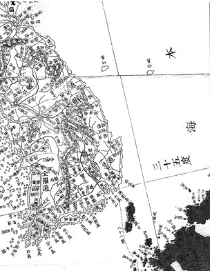 | 304 × 393 (93 KB) | Maintenance script (talk | contribs) | == Summary == Importing file |
You cannot overwrite this file.
File usage
The following page uses this file: