Niagara Escarpment: Difference between revisions
George Swan (talk | contribs) (add image) |
No edit summary |
||
| (One intermediate revision by one other user not shown) | |||
| Line 1: | Line 1: | ||
{{subpages}} | {{subpages}} | ||
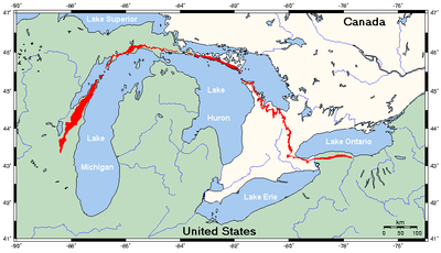
{{Image|Niagara Escarpment map.png|right|400px|Map of the Niagara Escarpment.}} | {{Image|Niagara Escarpment map.png|right|400px|Map of the Niagara Escarpment.}} | ||
The '''Niagara Escarpment''' is an [[escarpment]] visible in the US States of [[Wisconsin (U.S. state)|Wisconsin]] and [[New York (U.S. state)|New York]], and the Canadian Province of [[Ontario]]. The escarpment is tall, and its most well-known | The '''Niagara Escarpment''' is an [[escarpment]] visible in the US States of [[Wisconsin (U.S. state)|Wisconsin]] and [[New York (U.S. state)|New York]], and the Canadian Province of [[Ontario]]. The escarpment is tall, and its most well-known features are the falls at [[Niagara Falls]]. In New York State the escarpment runs from east to west, close to the southern shore of [[Lake Ontario]]. In Ontario it also runs parallel to the southern shore of Lake Ontario, where it suddenly turns north. The rest of its course curves into a circular arc centered in [[Michigan (U.S. state)|Michigan]]. Michigan's underlying geology is a [[syncline]] - a bowl. The Niagara escarpment owes its prominence to a particularly hard layer of [[Dolomite]], a sedimentary rock. Lower and softer layers were eroded away, forming the bluffs of the escarpment. | ||
After turning north, in Ontario, the escarpment forms the shore of [[Lake Huron]] and its [[Bruce Peninsula]]. A strait separates the Bruce Peninsula from [[Manitoulin Island]], the largest fresh water island on Planet Earth. The escarpment forms the northern shore of Manitoulin Island, and the southern shore of the [[Mackinac strait]]. Then it forms the western shore of [[Lake Michigan]]. | After turning north, in Ontario, the escarpment forms the shore of [[Lake Huron]] and its [[Bruce Peninsula]]. A strait separates the Bruce Peninsula from [[Manitoulin Island]], the largest fresh water island on Planet Earth. The escarpment forms the northern shore of Manitoulin Island, and the southern shore of the [[Mackinac strait]]. Then it forms the western shore of [[Lake Michigan]]. | ||
<gallery> | <gallery> | ||
File:On306 Niagara escarpment at Kelso 1965 (51186771203).jpg | File:On306 Niagara escarpment at Kelso 1965 (51186771203).jpg | ||
File:Niagara Escarpment Beamers Falls 01 (cropped).jpg | |||
File:Kelso Conservation Area- Escarpment - Milton Heights-Ontario (2).jpg | |||
</gallery> | </gallery> | ||
Latest revision as of 14:04, 10 November 2023
The Niagara Escarpment is an escarpment visible in the US States of Wisconsin and New York, and the Canadian Province of Ontario. The escarpment is tall, and its most well-known features are the falls at Niagara Falls. In New York State the escarpment runs from east to west, close to the southern shore of Lake Ontario. In Ontario it also runs parallel to the southern shore of Lake Ontario, where it suddenly turns north. The rest of its course curves into a circular arc centered in Michigan. Michigan's underlying geology is a syncline - a bowl. The Niagara escarpment owes its prominence to a particularly hard layer of Dolomite, a sedimentary rock. Lower and softer layers were eroded away, forming the bluffs of the escarpment.
After turning north, in Ontario, the escarpment forms the shore of Lake Huron and its Bruce Peninsula. A strait separates the Bruce Peninsula from Manitoulin Island, the largest fresh water island on Planet Earth. The escarpment forms the northern shore of Manitoulin Island, and the southern shore of the Mackinac strait. Then it forms the western shore of Lake Michigan.


