Lake Ontario: Difference between revisions
imported>George Swan |
mNo edit summary |
||
| (8 intermediate revisions by 3 users not shown) | |||
| Line 1: | Line 1: | ||
{{subpages}} | {{subpages}} | ||
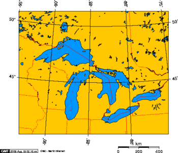
{{Image|North American Great Lakes.png|right|350px| Lake Ontario is the Easternmost of the five North American Great Lakes.}} | |||
'''Lake Ontario''' is | '''Lake Ontario''' is the eastern-most of the five [[North American Great Lakes]]. The [[Canada|Canadian]] province of [[Ontario]] is on the Lake Ontario's north shore, and [[New York (U.S. state)]] is on the lake's south shore. The [[Welland Canal]], at its west end, allows vessels to travel from Lake Ontario to Lake Erie. The largest city on the lake shore is [[Toronto, Ontario]]. | ||
==Limnology== | ==Limnology== | ||
| Line 10: | Line 10: | ||
Lake Ontario's [[dwell time]] is six years -- six years pass before water enters from the [[Niagara River]] and flows out the [[St Lawrence River]]. | Lake Ontario's [[dwell time]] is six years -- six years pass before water enters from the [[Niagara River]] and flows out the [[St Lawrence River]]. | ||
==Lake Ontario during the latest glaciation== | ==Lake Ontario during the latest glaciation== | ||
| Line 34: | Line 26: | ||
As the glacier retreated a series of [[glacial lakes]] formed in the area of the current lakes. As the glacier retreated from the region of Lake Ontario it retreated from west to east, so it continued to block outflow down what is now the valley of the St Lawrence River. The lake that formed in the basin was close to 50 metres deeper than lake Ontario, and the outflow of the Great Lakes flowed down the [[Hudson River]], and its [[tributary]], the [[Mohawk River]]. | As the glacier retreated a series of [[glacial lakes]] formed in the area of the current lakes. As the glacier retreated from the region of Lake Ontario it retreated from west to east, so it continued to block outflow down what is now the valley of the St Lawrence River. The lake that formed in the basin was close to 50 metres deeper than lake Ontario, and the outflow of the Great Lakes flowed down the [[Hudson River]], and its [[tributary]], the [[Mohawk River]]. | ||
The ancient glacial lake was known as [[Lake Iroquois]].<ref name=lostrivers> | The ancient glacial lake was known as [[Lake Iroquois]].<ref name=lostrivers/> | ||
A geologic feature associated with the lake is [[Scotch Bonnet Ridge]]. | |||
The valley through which the glacial Mohawk River flowed is the only navigable water route across the [[Appalachian Mountains]]. Prior to development of [[railroad]] networks the [[Erie Canal]], which parallels the mohawk river, | The valley through which the glacial Mohawk River flowed is the only navigable water route across the [[Appalachian Mountains]]. Prior to development of [[railroad]] networks the [[Erie Canal]], which parallels the mohawk river, | ||
| Line 40: | Line 34: | ||
==References== | ==References== | ||
<references/> | <references/>[[Category:Suggestion Bot Tag]] | ||
Latest revision as of 16:00, 9 September 2024
Lake Ontario is the eastern-most of the five North American Great Lakes. The Canadian province of Ontario is on the Lake Ontario's north shore, and New York (U.S. state) is on the lake's south shore. The Welland Canal, at its west end, allows vessels to travel from Lake Ontario to Lake Erie. The largest city on the lake shore is Toronto, Ontario.
Limnology
Of the five lakes Lake Ontario has the the smallest surface area. But Lake Erie is unlike the other lakes, it is much shallower, and it is lake with the smallest volume.
Lake Ontario's dwell time is six years -- six years pass before water enters from the Niagara River and flows out the St Lawrence River.
Lake Ontario during the latest glaciation
At the peak of the recent Laurentide Glaciation all of the North American Great Lakes were covered by a continent-spanning glacier.[1] As the glacier retreated a series of glacial lakes formed in the area of the current lakes. As the glacier retreated from the region of Lake Ontario it retreated from west to east, so it continued to block outflow down what is now the valley of the St Lawrence River. The lake that formed in the basin was close to 50 metres deeper than lake Ontario, and the outflow of the Great Lakes flowed down the Hudson River, and its tributary, the Mohawk River.
The ancient glacial lake was known as Lake Iroquois.[1]
A geologic feature associated with the lake is Scotch Bonnet Ridge.
The valley through which the glacial Mohawk River flowed is the only navigable water route across the Appalachian Mountains. Prior to development of railroad networks the Erie Canal, which parallels the mohawk river, was the most practical route for the transport of bulk cargo across the Appalachians.
References
- ↑ 1.0 1.1 Lake Iroquois: and its shore cliff or bluff, Toronto Green Community and Toronto Field Naturalists. Retrieved on 2008-08-20.
