Seychelles: Difference between revisions
imported>John Stephenson ({{speedydelete|too short a stub; also, is the image permitted to be used?|~~~~}}) |
mNo edit summary |
||
| (17 intermediate revisions by 8 users not shown) | |||
| Line 1: | Line 1: | ||
{{ | {{subpages}} | ||
The '''Republic of Seychelles''' is an island nation in the [[Indian Ocean]]. The archipelago lies northeast of [[Madagascar]]. | [[Image:Seychelles.gif|right|200px]] | ||
The '''Republic of Seychelles''' is an island nation in the [[Indian Ocean]]. The archipelago lies northeast of [[Madagascar]] and 1,000 miles east of [[Kenya]]. With a population of 80,000, it is the smallest sovereign [[Africa|African]] nation. Most citizens are of mixed French and East African ancestry.<ref name=CIA> ''[https://www.cia.gov/cia/publications/factbook/geos/se.html The World Factbook, Seychelles], CIA (2007) </ref> | |||
==History== | |||
The Seychelles have been known to seafaring people in the area long before permanent settlements appeared. Arabs charted the islands in the 9th and 10th centuries, as did Portuguese explorers in 1505. In 1609, Alexander Sharpeigh of the [[British East India Company]] landed on the islands and found them uninhabited. <ref name= Pre_Settlement> [http://www.virtualseychelles.sc/pecu/pecu_his_preset.htm Pre settlement history], Republic of Seychelles website</ref> | |||
<ref>Jourdain, John-William Foster; ''Journal of John Jourdain'' from the ''Ascension'', A British East India Company ship piloted by Sharpeigh; First published 1905, Cambridge</ref> | |||
Lazare Picault explored the islands in 1742, and the Sechelles were officially annexed by France in 1756 and named after French minister of finance under King Louis XV, Jean Moreau de Séchelles (1690-1760). The French created a supply outpost that grew crops and harvested natural resources, decimating the giant tortoises population and hardwood forests. | |||
The Seychelles during this time were dependant on [[Mauritius]], and after a lengthy struggle with Britain, possession of both were ceded by France in 1814. In 1903 The Seychelles becam a British Crown Colony, ending their political connection to Mauritius. | |||
The colony gradually moved towards independence during the 20th century; in 1948 a Legislative Council was created; in 1970 a new constitution was adopted; and in 1975 the first self-government was created, with James R. Mancham the first president and France-Albert René the prime minister. | |||
France-Albert René became president in a [[coup d'état]] in 1977, and by 1979 the Seychelles had become a one-party socialist state, with the FPPS (Seychelles People's Progressive Front) in power. A new constitution was created and free elections held in 1993. In 2004 René, in power since 1977, stepped down and the current president, James Michel, became both the Head of State and head of government. | |||
Among the many pirates who used the Seychelles, the most famous was 'La Buze' - Olivier Le Vasseur, captured by the French and hanged on July 7, 1730 in Isle de France (Mauritius).<ref name=Carpin>Carpin, Sarah;''Seychelles: Garden of Eden in the Indian Ocean''; Publisher Odyssey (Hong Kong)</ref> | |||
==Geography== | |||
{{Image|Grand Anse-La Digue-Seychellen.jpg|right|350px|The Seychelles are famous for their beautiful beaches. Here, the beach of Grand Anse on the island of [[La Digue]].}} | |||
Located at [http://mapper.acme.com/?ll=-4.64760,55.45898&z=8&t=M 4°S 50°E], the Seychelles are two groups of islands, about 120 in total, making up 444 square kilometers of land. Mahé is the main island and location of the capitol city Vicoria. Within about 90 KM of Mahé are some 40 other islands with similar granitic and hilly geography. Average rainfall on Mahé is 2,880 mm at sea level and 3,550 on its slopes. The granite composition of the main islands is unique for archipelagos. | |||
A second group of islands make up the rest of the archipelago. These are flat and corillian with little fresh water and spread over 1,200 Km from northeast to southwest.<ref name=USGS> Thomas R. Yager (2003), [http://minerals.usgs.gov/minerals/pubs/country/2003/bycnmimpfrrwsemyb03.pdf Teg Mineral Idustries of Burundi, Comoros, Malawi, Mauritius, Reunion, Rwanda, and Seychelles], USGS</ref> | |||
The climate is tropical-oceanic with little yearly temperature variation.<ref name=FAO>Seychelles (2005); Food and Agriculture organization of the United Nations</ref> | |||
The Seychelles is one of the few places on earth with no natural hazards to humans. There is no Malaria or serious endemic disease; it lies outside of the cyclone belts; the weather is warm and mild year around. <ref name=Carpin/> | |||
==Flora and fauna== | |||
{{Image|Coco de Mer palm.jpg|right|200px|Seychelles nut.}} | |||
The islands are tropical and lush and home to the Coco de Mer palm (Seychelles nut), largest seed in the plant kingdom<ref name=NOVA>''[http://www.pbs.org/wgbh/nova/transcripts/2714eden.html NOVA transcript Garden of Eden]''(2000); NOVA, PBS</ref> | |||
Several unique tortoises and turtles orriginate from the islands; the Seychelles giant tortoise, hunted to extinction in the wild; the Aldabra Giant Tortoise, named after the Seychelle's Aldabra Atoll ([http://mapper.acme.com/?ll=-9.43822,46.30737&z=11&t=S&marker0=-9.40000%2C46.36666%2C9%25C2%25B024%25E2%2580%25B2S%2046%25C2%25B022%25E2%2580%25B2E S 9.43822 E 46.30737]); the Hawksbill Turtle (Critically Endangered); and the Green Turtle (Endangered). | |||
==References== | ==References== | ||
<references/>[[Category:Suggestion Bot Tag]] | |||
[[Category: | |||
Latest revision as of 11:01, 17 October 2024
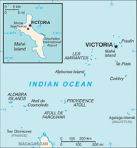
The Republic of Seychelles is an island nation in the Indian Ocean. The archipelago lies northeast of Madagascar and 1,000 miles east of Kenya. With a population of 80,000, it is the smallest sovereign African nation. Most citizens are of mixed French and East African ancestry.[1]
History
The Seychelles have been known to seafaring people in the area long before permanent settlements appeared. Arabs charted the islands in the 9th and 10th centuries, as did Portuguese explorers in 1505. In 1609, Alexander Sharpeigh of the British East India Company landed on the islands and found them uninhabited. [2] [3]
Lazare Picault explored the islands in 1742, and the Sechelles were officially annexed by France in 1756 and named after French minister of finance under King Louis XV, Jean Moreau de Séchelles (1690-1760). The French created a supply outpost that grew crops and harvested natural resources, decimating the giant tortoises population and hardwood forests.
The Seychelles during this time were dependant on Mauritius, and after a lengthy struggle with Britain, possession of both were ceded by France in 1814. In 1903 The Seychelles becam a British Crown Colony, ending their political connection to Mauritius.
The colony gradually moved towards independence during the 20th century; in 1948 a Legislative Council was created; in 1970 a new constitution was adopted; and in 1975 the first self-government was created, with James R. Mancham the first president and France-Albert René the prime minister.
France-Albert René became president in a coup d'état in 1977, and by 1979 the Seychelles had become a one-party socialist state, with the FPPS (Seychelles People's Progressive Front) in power. A new constitution was created and free elections held in 1993. In 2004 René, in power since 1977, stepped down and the current president, James Michel, became both the Head of State and head of government.
Among the many pirates who used the Seychelles, the most famous was 'La Buze' - Olivier Le Vasseur, captured by the French and hanged on July 7, 1730 in Isle de France (Mauritius).[4]
Geography

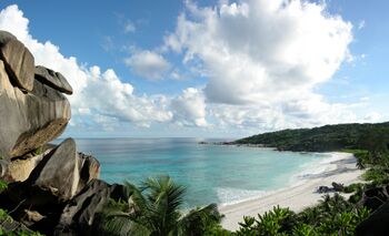
The Seychelles are famous for their beautiful beaches. Here, the beach of Grand Anse on the island of La Digue.
Located at 4°S 50°E, the Seychelles are two groups of islands, about 120 in total, making up 444 square kilometers of land. Mahé is the main island and location of the capitol city Vicoria. Within about 90 KM of Mahé are some 40 other islands with similar granitic and hilly geography. Average rainfall on Mahé is 2,880 mm at sea level and 3,550 on its slopes. The granite composition of the main islands is unique for archipelagos.
A second group of islands make up the rest of the archipelago. These are flat and corillian with little fresh water and spread over 1,200 Km from northeast to southwest.[5]
The climate is tropical-oceanic with little yearly temperature variation.[6]
The Seychelles is one of the few places on earth with no natural hazards to humans. There is no Malaria or serious endemic disease; it lies outside of the cyclone belts; the weather is warm and mild year around. [4]
Flora and fauna
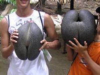
The islands are tropical and lush and home to the Coco de Mer palm (Seychelles nut), largest seed in the plant kingdom[7]
Several unique tortoises and turtles orriginate from the islands; the Seychelles giant tortoise, hunted to extinction in the wild; the Aldabra Giant Tortoise, named after the Seychelle's Aldabra Atoll (S 9.43822 E 46.30737); the Hawksbill Turtle (Critically Endangered); and the Green Turtle (Endangered).
References
- ↑ The World Factbook, Seychelles, CIA (2007)
- ↑ Pre settlement history, Republic of Seychelles website
- ↑ Jourdain, John-William Foster; Journal of John Jourdain from the Ascension, A British East India Company ship piloted by Sharpeigh; First published 1905, Cambridge
- ↑ 4.0 4.1 Carpin, Sarah;Seychelles: Garden of Eden in the Indian Ocean; Publisher Odyssey (Hong Kong)
- ↑ Thomas R. Yager (2003), Teg Mineral Idustries of Burundi, Comoros, Malawi, Mauritius, Reunion, Rwanda, and Seychelles, USGS
- ↑ Seychelles (2005); Food and Agriculture organization of the United Nations
- ↑ NOVA transcript Garden of Eden(2000); NOVA, PBS

