Wulanhaote: Difference between revisions
imported>Derek Harkness (This article was writen entirely by me. It is based on an article I wrote for wikipedia but has now been significantly expanded and reworded.) |
mNo edit summary |
||
| (3 intermediate revisions by 3 users not shown) | |||
| Line 1: | Line 1: | ||
{{subpages}} | |||
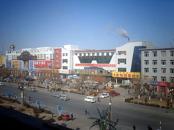
{{Image|Wulanhaote City Street - Inner Mongolia - China.JPG|right|350px|A main street of Wulanhaote near to the train station.}} | |||
'''Wūlánhàotè Shì''' (Simplified Chinese: '''乌兰浩特市''', Mongolian: '''Horqin Youyi Qianqi''', Wade-Giles: '''Ulan Hot''', Other forms: '''Ulaanhot''', Formerly: Wangiin Süme) is a county-level city in the East of the [[Inner Mongolia Autonomous Region]] of the [[People's Republic of China]]. It is about 50 miles due north of [[Baicheng]] city of [[Jilin]] province. Between the years 1947 and 1950, Wulanhaote was the capital of Inner Mongolia Region.<ref>Governing China's Multiethnic Frontiers By Rossabi, Published 2005, University of Washington Press, 296 pages, ISBN 0295984120</ref> In 1950, the capital moved to Zhangjiakou and then again in 1952 to Hohhot, which remains the capital of the region to this day. The city is populated predominantly by Han Chinese but has a significant Mongolian population. | '''Wūlánhàotè Shì''' (Simplified Chinese: '''乌兰浩特市''', Mongolian: '''Horqin Youyi Qianqi''', Wade-Giles: '''Ulan Hot''', Other forms: '''Ulaanhot''', Formerly: Wangiin Süme) is a county-level city in the East of the [[Inner Mongolia Autonomous Region]] of the [[People's Republic of China]]. It is about 50 miles due north of [[Baicheng]] city of [[Jilin]] province. Between the years 1947 and 1950, Wulanhaote was the capital of Inner Mongolia Region.<ref>Governing China's Multiethnic Frontiers By Rossabi, Published 2005, University of Washington Press, 296 pages, ISBN 0295984120</ref> In 1950, the capital moved to Zhangjiakou and then again in 1952 to Hohhot, which remains the capital of the region to this day. The city is populated predominantly by Han Chinese but has a significant Mongolian population. | ||
There are several state run schools at elementary, middle school and high school levels in Wulanhaote and the surrounding villages. Aside form the regular Chinese schools, there are several Ethnic Mongolian schools. These Mongolian schools have predominantly Mongolian students and teachers. They teach in the Mongolian tongue and script and study Mandarin Chinese as second languages. There are also many small private schools in the city. These specialise in evening and weekend classes to supplement the state education. | There are several state run schools at elementary, middle school and high school levels in Wulanhaote and the surrounding villages. Aside form the regular Chinese schools, there are several Ethnic [[Mongolian]] schools. These Mongolian schools have predominantly Mongolian students and teachers. They teach in the Mongolian tongue and script and study [[Mandarin Chinese]] and English as second languages. There are also many small private schools in the city. These specialise in evening and weekend classes to supplement the state education. | ||
Wulanhaote is connected by the [[Trans-Siberia]] railway, which runs through the pass south of Wulanhaote, to [[Baicheng]] City in [[Jilin]] province. A distance of about 50 miles. China's National Highway 302 runs from [[Tumen]] in [[Jilin]] to Wulanhoaote. In the [[National_Trunk_Highway_System#Network|7918 Network]] of Highways it will be on the route from Hunchun to Wulanhoaote. The city is also served by [[Ulanhot Airport]] ([[ICAO]] code ZBUL and [[IATA]] code HLH). Routes flown by [[Air China]] and [[Hainan Airlines]] connect Wulanhaote with [[Beijing Capital International Airport]]. | |||
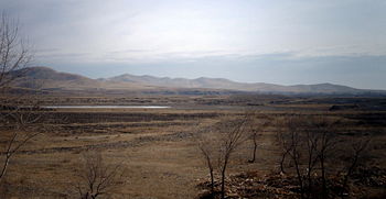
The city is largely a market town for the surrounding farmers. A large dairy factory forms the main industry. The city has a horse racecourse which provides the main sporting attraction. The center of the city is formed around a large square which is used to stage a variety of entertainments. On the northern edge of the city is a tomb from the [[Yuan dynasty]] and a temple dedicated to [[Genghis Khan]] (1167-1227). The temple was constructed in 1940. The temple covered an area of 822 square metres<ref>The Mongols at China's Edge: History and the Politics of National Unity By Uradyn Erden Bulag, Published 2002, Rowman & Littlefield, 288 pages, ISBN 0742511448</ref> until the year 2002 when it received funds for significant expansion.<ref> http://english.peopledaily.com.cn/200209/04/eng20020904_102605.shtml </ref> This is the only temple in the world which commemorate Genghis Khan. | {{Image|Eastern Inner Mongolian country side - China.JPG|right|350px|The Mongolian plains around Wulanhaote are dry with little rainfall.}}The city is largely a market town for the surrounding farmers. A large dairy factory forms the main industry. The city has a horse racecourse which provides the main sporting attraction. The center of the city is formed around a large square which is used to stage a variety of entertainments. On the northern edge of the city is a tomb from the [[Yuan dynasty]] and a temple dedicated to [[Genghis Khan]] (1167-1227). The temple was constructed in 1940. The temple covered an area of 822 square metres<ref>The Mongols at China's Edge: History and the Politics of National Unity By Uradyn Erden Bulag, Published 2002, Rowman & Littlefield, 288 pages, ISBN 0742511448</ref> until the year 2002 when it received funds for significant expansion.<ref> http://english.peopledaily.com.cn/200209/04/eng20020904_102605.shtml </ref> This is the only temple in the world which commemorate Genghis Khan. | ||
The surrounding land is semi-arid. Rainfall is infrequent in this area. Following a Asian monsoon weather pattern, the summers are very hot and winters are very cold. The land is generally flat plains spotted with isolated hills or small mountains. | The surrounding land is semi-arid. Rainfall is infrequent in this area. Following a Asian monsoon weather pattern, the summers are very hot and winters are very cold. The land is generally flat plains spotted with isolated hills or small mountains. | ||
| Line 12: | Line 14: | ||
<references/> | <references/> | ||
[[Category: | [[Category:Suggestion Bot Tag]] | ||
Latest revision as of 12:01, 9 November 2024
Wūlánhàotè Shì (Simplified Chinese: 乌兰浩特市, Mongolian: Horqin Youyi Qianqi, Wade-Giles: Ulan Hot, Other forms: Ulaanhot, Formerly: Wangiin Süme) is a county-level city in the East of the Inner Mongolia Autonomous Region of the People's Republic of China. It is about 50 miles due north of Baicheng city of Jilin province. Between the years 1947 and 1950, Wulanhaote was the capital of Inner Mongolia Region.[1] In 1950, the capital moved to Zhangjiakou and then again in 1952 to Hohhot, which remains the capital of the region to this day. The city is populated predominantly by Han Chinese but has a significant Mongolian population.
There are several state run schools at elementary, middle school and high school levels in Wulanhaote and the surrounding villages. Aside form the regular Chinese schools, there are several Ethnic Mongolian schools. These Mongolian schools have predominantly Mongolian students and teachers. They teach in the Mongolian tongue and script and study Mandarin Chinese and English as second languages. There are also many small private schools in the city. These specialise in evening and weekend classes to supplement the state education.
Wulanhaote is connected by the Trans-Siberia railway, which runs through the pass south of Wulanhaote, to Baicheng City in Jilin province. A distance of about 50 miles. China's National Highway 302 runs from Tumen in Jilin to Wulanhoaote. In the 7918 Network of Highways it will be on the route from Hunchun to Wulanhoaote. The city is also served by Ulanhot Airport (ICAO code ZBUL and IATA code HLH). Routes flown by Air China and Hainan Airlines connect Wulanhaote with Beijing Capital International Airport.
The city is largely a market town for the surrounding farmers. A large dairy factory forms the main industry. The city has a horse racecourse which provides the main sporting attraction. The center of the city is formed around a large square which is used to stage a variety of entertainments. On the northern edge of the city is a tomb from the Yuan dynasty and a temple dedicated to Genghis Khan (1167-1227). The temple was constructed in 1940. The temple covered an area of 822 square metres[2] until the year 2002 when it received funds for significant expansion.[3] This is the only temple in the world which commemorate Genghis Khan.
The surrounding land is semi-arid. Rainfall is infrequent in this area. Following a Asian monsoon weather pattern, the summers are very hot and winters are very cold. The land is generally flat plains spotted with isolated hills or small mountains.
References
- ↑ Governing China's Multiethnic Frontiers By Rossabi, Published 2005, University of Washington Press, 296 pages, ISBN 0295984120
- ↑ The Mongols at China's Edge: History and the Politics of National Unity By Uradyn Erden Bulag, Published 2002, Rowman & Littlefield, 288 pages, ISBN 0742511448
- ↑ http://english.peopledaily.com.cn/200209/04/eng20020904_102605.shtml

