File:Great Salt Lake ISS 2003.jpg: Difference between revisions
Jump to navigation
Jump to search
imported>Margaret reinlieb ({{Image notes wikimedia |Description=Great Salt Lake, Utah, to the right (east) are the Wasatch Mountains, to the lower right is Salt Lake City, Utah. This photo is taken from the International Space Station from approximately 380 km. The railway clearly separates the north and south sections of the lake, which have different salt concentrations due to the barrier. The water level of the lake is very low: note how the northeast arm of the lake has disappeared, and how Antelope Island isn't an...) |
imported>Caesar Schinas m (Bot: Replace Template:Image_notes_* with Template:Image_Details) |
||
| Line 1: | Line 1: | ||
{{ | {{Image_Details | ||
| | | description = Great Salt Lake, Utah, to the right (east) are the Wasatch Mountains, to the lower right is Salt Lake City, Utah. This photo is taken from the International Space Station from approximately 380 km. The railway clearly separates the north and south sections of the lake, which have different salt concentrations due to the barrier. The water level of the lake is very low: note how the northeast arm of the lake has disappeared, and how Antelope Island isn't an island at all. | ||
| | | author = NASA's Earth Observatory {{#if:http://eol.jsc.nasa.gov/scripts/sseop/photo.pl?mission=ISS007&roll=E&frame=13002|(http://eol.jsc.nasa.gov/scripts/sseop/photo.pl?mission=ISS007&roll=E&frame=13002)}} | ||
| copyright = NASA's Earth Observatory | |||
| | | source = http://commons.wikimedia.org/wiki/File:Great_Salt_Lake_ISS_2003.jpg | ||
| | | date-created = 19 August 2003, GMT time: 16:37 | ||
| | | pub-country = | ||
| | | notes = | ||
| versions = | |||
}} | |||
Revision as of 02:56, 22 June 2009
| Title / Description
|
Great Salt Lake, Utah, to the right (east) are the Wasatch Mountains, to the lower right is Salt Lake City, Utah. This photo is taken from the International Space Station from approximately 380 km. The railway clearly separates the north and south sections of the lake, which have different salt concentrations due to the barrier. The water level of the lake is very low: note how the northeast arm of the lake has disappeared, and how Antelope Island isn't an island at all. |
|---|---|
| Author(s)
|
NASA's Earth Observatory (http://eol.jsc.nasa.gov/scripts/sseop/photo.pl?mission=ISS007&roll=E&frame=13002) |
| Copyright holder
|
NASA's Earth Observatory See below for license/re-use information. |
| Source
|
http://commons.wikimedia.org/wiki/File:Great_Salt_Lake_ISS_2003.jpg |
| Date created
|
19 August 2003, GMT time: 16:37 |
| Country of first publication
|
Please edit this page and add the country of first publication, or note that it is unknown. |
| Notes
|
You can edit this page and add notes here which may be useful to people who wish to re-use this media. |
| Other versions
|
If there are other versions of this media on CZ, please list them here. |
| Using this image on CZ
|
, then copy the code below to add this image to a Citizendium article, changing the size, alignment, and caption as necessary.
|
Image issue? Contact us via the email below.
Please send email to manager A T citizendium.org .
File history
Click on a date/time to view the file as it appeared at that time.
| Date/Time | Thumbnail | Dimensions | User | Comment | |
|---|---|---|---|---|---|
| current | 19:57, 11 March 2022 | 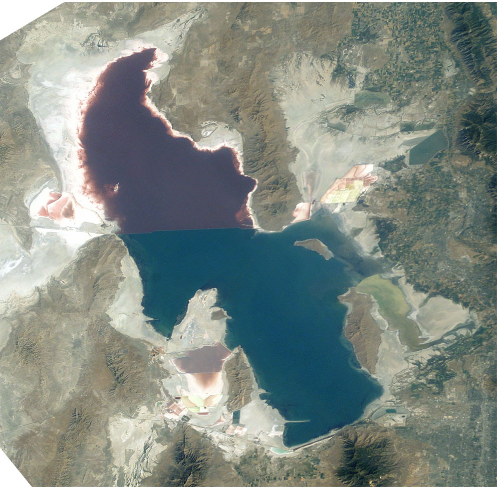 | 996 × 976 (248 KB) | Maintenance script (talk | contribs) | == Summary == Importing file |
You cannot overwrite this file.
File usage
The following 3 files are duplicates of this file (more details):
- File:Great Salt Lake ISS 2003.jpg from a shared repository
- File:Great Salt Lake ISS 2003.jpg from Wikimedia Commons
- File:ISS007-E-13002.jpg
There are no pages that use this file.