File:NOAA map of Duck Galloo Ridge (cropped) showing Timber, Swetman, Main Duck and Yorkshire islands, and some subsurface shoals.jpg
Jump to navigation
Jump to search

Size of this preview: 800 × 488 pixels. Other resolution: 1,026 × 626 pixels.
Original file (1,026 × 626 pixels, file size: 647 KB, MIME type: image/jpeg)
| Description |
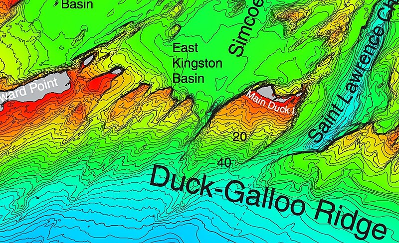
This detail from a NOAA map of Duck Galloo Ridge shows the Northeast corner of Lake Ontario. As lakes go Lake Ontario is relatively deep. The portion north of this ridge is significantly less deep. This detail shows Swetman Island, Timber Island, Main Duck Island, and Yorkshire Island, and some subsurface shoals. |
|||
| Source | https://ngdc.noaa.gov/mgg/greatlakes/lakeontario_cdrom/html/newnames.htm | |||
| Author | ||||
| Permission (Reusing this file) |
|
|||
| Other versions |

_showing_Timber,_Swetman,_Main_Duck_and_Yorkshire_islands,_and_some_subsurface_shoals.jpg)
File history
Click on a date/time to view the file as it appeared at that time.
| Date/Time | Thumbnail | Dimensions | User | Comment | |
|---|---|---|---|---|---|
| current | 13:55, 2 April 2019 | | 1,026 × 626 (647 KB) | imagescommonswiki>Geo Swan | File:NOAA map of Duck Galloo Ridge.jpg cropped 63 % horizontally, 72 % vertically using CropTool with precise mode. |
File usage
The following file is a duplicate of this file (more details):
_showing_Timber,_Swetman,_Main_Duck_and_Yorkshire_islands,_and_some_subsurface_shoals.jpg)
The following 3 pages use this file:
_showing_Timber,_Swetman,_Main_Duck_and_Yorkshire_islands,_and_some_subsurface_shoals.jpg)