North-West Frontier Province

From Citizendium
Revision as of 17:11, 15 February 2024 by John Leach (talk | contribs) (map)
Jump to navigation Jump to search
This article is a stub and thus not approved.
Main Article
Discussion
Related Articles  [?]
Bibliography  [?]
External Links  [?]
Citable Version  [?]
 
This editable Main Article is under development and subject to a disclaimer.
(CC) Image: Pahari Sahib
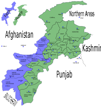
This map shows the location of FATA (blue) in relation to NWFP (green) and their neighbours. Broadly, the blue and green areas were combined as Khyber Pakhtunkhwa in 2018. Within FATA are its seven semi-autonomous Tribal Agencies.

The North-West Frontier Province existed from 1901 to 1955, and from 1970 to 2010. Until 1947, it was part of British India, and then of Pakistan. The province was disestablished in 1955 as part of an administrative reorganisation but then revived in 1970. In April 2010, it was reconstituted as the new province of Khyber Pakhtunkhwa.